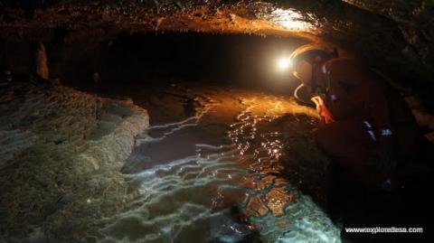
Adventure Cave Exploration is darkness, Silent, Wet adventure
Indonesia is one of land with thousand Cave in The world, and still waiting to explorer by Cavers Adventure, Geologist or just Hobbies for fun Caving is a truly memorable experience and gives you the opportunity to see the hidden side of our limestone areas. For a first really adventurous trip underground it’s a good idea to book on to a guided trip. This will see you properly equipped and in experienced hands Want to try caving but not sure where to begin? Try a show cave. These offer guided underground adventures that don’t involve crawling around on your hands and knees and also combine your adventure with Volcano Trekking tour, or Eco Adventure in Indonesia, we will very happy to help you. [picasaView album=”JavaVolcanoesAdventureTour” instantView=”yes”]
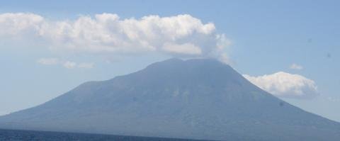
Ile Lewotolo Volcano raised from Normal to be alert Status
Ile Leotolo Volcano is located on the Ile Lewotolo Lembata District, East Nusa Tenggara province, geographically located at position 08 ° 16’15 “latitude and 123 ° 30’18” E with an altitude of 1455 meters above sea level (asl). This volcano had rested 92 years. The last eruption occurred in 1920 a small eruption. Previous eruptions have been recorded be some times that in 1660, 1819, 1849, 1852, 1821, 1864, 1889, and 1920, 1999 September 1st, 2003 An erupting volcano in eastern Indonesia has forced villagers living on its slopes to flee showers of hot ash. The state Antara news agency says the 1,700-metre Mount Lewotobi on Flores island erupted on Sunday evening and was still spewing hot ash on Monday. Residents of at least six villages have fled their homes and are being taken to Konga village, which has not been affected by the eruption. Later reports say that Lewotobi…
increase in the intensity of Lava avalanches at Mount Semeru
crater at the summit of Mount Semeru, Saturday, November 26, 2011, reportedly continues to abort the volcanic material into the deep abyss of the crater to the southeast. based on information compiled from the Volcano Observation Post (PGA) Mount Semeru at Mount Sawur, Sumberwuluh Village, District Candipuro, Lumajang, East Java, this morning, occurred seven times avalanches of volcanic material. “The status of volcanic activity of Mount Semeru remained at the level of alert,” increase in the intensity of Lava avalanches have occurred since Wednesday, November 23, 2011 last. At that time, avalanches occurred six times.Lava Avalanches of volcanic material re-occurred on Friday, 25 November 2011, although only one time PGA Head Post Mount Semeru, Suparno, through its letter to the Government Lumajang explained that PVMBG asked residents not to perform the activity in the region as far as four kilometers around the southeastern slopes of the crater which is the…